
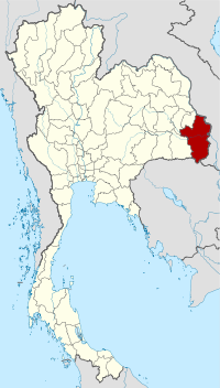
While Khon Kaen may be the heart of Isaan, we reckon the province of Ubon Ratchathani is the very underrated soul of Isaan. Isaan's second largest province (after Nakhon Ratchasima), Ubon Ratchathani is bordered to the south by Cambodia and to the east by Laos, making it part of the so-calledEmerald Triangle the forested and well-mined meeting point of Thailand, Cambodia and Laos. Ubon, as it is commonly known, is home to an eclectic mix of ethnicities, including Khmer, Laotians, Vietnamese, Japanese, Chinese and Thais, who above all else have created an excellent food scene.
The capital, Ubon Ratchathani(Royal City of the Lotus), sits towards the western side of the same-named province. Once a centre for Dvaravati and Khmer cultures, today this lively city is the trading and communications hub of eastern Isaan. To the casual visitor, it may appear to be nothing more than a scaled down version of Bangkok -- rush hour traffic included -- but get off the main drag, away from the fast food joints and mobile phone stores and you'll find a well-preserved Isaan community offering much to teach about the traditional region.
Ever since the Chong Mek/Vang Tao border crossing to Laos opened, there has been a steadily increasing trickle of tourists and independent travellers passing through Ubon. Before this border with southern Laos opened, Ubon Ratchathani was best known among those looking to practise their meditation, with a few very well regarded forest wats in the province. Today, despite the fact that the province has a lot to offer for independent travellers, the vast majority see Ubon Ratchathani as nothing more than an overnight stop en route to southern Laos.
The city has a well-established reputation as a religious teaching centre; aside from several highly revered forest wats, there are numerous typical (and not-so-typical) Thai wats in the centre of town as well as an educational museum, all of which are easily accessible. City sights aside, indulging your taste buds and senses in Ubon's excellent food and drink scene is an activity in itself and it makes a great base for exploring the reasonable range of attractions around the province.
Aside from the bustling provincial capital, a range of national parks, including the impressive Pha Taem National Park stretch across the province and there is an ample supply of pleasant riverside options to lose a day or two. Best explored with a hired motorcycle or driver, some of the main attractions can still be reached by public transport. While Si Saket is closer, it is possible to visit the spectacular Khmer ruins ofPrasat Khao Phra Viharn from Ubon Ratchathani.
Although the paddy scenery by road can be monotonously flat -- lush green when irrigated and straw yellow when not -- hills to the east leading to the Mekong and to the south, where the watershed forms the border with Cambodia, makes for some spectacular views.
Every July or August, Ubon Ratchathani hosts the Candle Festival to celebrate the beginning of Buddhist Lent with a parade of huge, finely-carved wax sculptures. While the event is most popular with Thais, it is still well worth a peek if you're interested in experiencing a traditional Thai festival.

Pha Taem National Park
Ancient graffiti
 Located about 25 kilometres north of Khong Chiam is Pha Taem National Park, where brilliant cliffside views of Laos can be had. Pha Taem is best explored by private transport to ensure you get your 200 baht admission fee's worth.
About a 500-metre walk from the main carpark to the base of the cliffs lies more than 300 prehistoric cave paintings estimated to be more than 3,000 years old.
The paintings were found by a professor and some students from Silpakorn University in 1981 and are believed to have been made over a very long period of time and tell the story of the people who made them. The earliest show human hands and a selection of animals while the newer show crops being planted, fish trapping and some primitive agricultural tools. Just above the base, spectacular views can be had of Laos, the Pa Dong Na Tham natural pine forest and Thailand's earliest sunset.
A major feature of the national park is the Phanon Dongrak mountain range, featuring many unique stone formations. The series of "mushroom" rock pillars, Sao Cha Liang, are similar to those found in Mukdahan National Park, 100 kilometres to the north of Ubon Ratchathani. The stone formations can be seen from the road once you enter the park.
North of these sites are three waterfalls: Soi Sawan, Saeng Chan and Thung Namuang. All are at their best during wet season and only reachable by private transport. Our favourite is Saeng Chan Waterfall which spills through a large hole in a rock rather than over a cliff and appears to fall in the shape of a heart. The name means "moonlight waterfall" because the attraction is supposedly best viewed by full moonlight. Another recommended viewing time is just before noon, when the sunlight hits the hole at the same angle as the falling water in a way that causes a glowing appearance.
Just past the falls, the park also boasts Thailand's largest flower field, blooming October until December.
Food and drinks are available in a shaded area by the car park. It's possible to rent camping equipment on site at Pha Taem during dry season, at 30 baht per person with your own tent or a two-person tent hire for 150 baht. A few extremely basic cabins and bungalows are available to rent, but overall we recommend staying in nearby Khong Chiam which has superior accommodation. Pha Taem is less than 20 kilometres from Khong Chian on Route 2112, and in town you can easily rent a motorbike or sign up for a tour to get to Pha Taem.
Food and drinks are available in a shaded area by the car park. It's possible to rent camping equipment on site at Pha Taem during dry season, at 30 baht per person with your own tent or a two-person tent hire for 150 baht. A few extremely basic cabins and bungalows are available to rent, but overall we recommend staying in nearby Khong Chiam which has superior accommodation. Pha Taem is less than 20 kilometres from Khong Chian on Route 2112, and in town you can easily rent a motorbike or sign up for a tour to get to Pha Taem.
Khong Chiam
Prehistoric Thai
graffiti
Around 60 kilometres to the east of Ubon Ratchathani at the confluence of the Moon and Mekong rivers ,Khong Chiam offers a quiet escape from the big smoke of Ubon Ratchathani.
The point where the two rivers meet is known as the Mae Nam Song Si or 'Two Colour River'. Sure enough, depending on the season, flow and heights of the two rivers, a slight difference in colour is evident from the river's bank due to the differing sediment levels in the Moon and Mekong Rivers.
From Khong Chiam boats can be arranged to whisk you out to the colour changing point. The best time of the year to see the differing colours is between March and May -- we don't recommend this boat trip during rainy season (June-October), as the rivers lose contrast from the murky water.
Boats may also be arranged across the Mekong from Khong Chiam to the Lao side of the river to visit the settlement there for 200-300 baht. While foreigners cannot enter further into Laos from here, persuading the immigration police to let you visit the market should take less than 100 baht. Or, travellers may hire a boatman to take them upriver to Pha Taem National Park for around 1,000 baht -- again ask around in Khong Chiam.
Boats may also be arranged across the Mekong from Khong Chiam to the Lao side of the river to visit the settlement there for 200-300 baht. While foreigners cannot enter further into Laos from here, persuading the immigration police to let you visit the market should take less than 100 baht. Or, travellers may hire a boatman to take them upriver to Pha Taem National Park for around 1,000 baht -- again ask around in Khong Chiam.
Aside from the two-colour river, if you're one for ticking activities off lists, you can view Thailand's earliest sunrise on the Mekong River from here.
As for Khong Chiam itself, it's a pretty sleepy town, but it is the closest spot to base yourself if you are planning on visiting the nearby Pha Taem National Park, Kaeng Tana National park, the border town of Chong Mek along with two nearby dams.
As for Khong Chiam itself, it's a pretty sleepy town, but it is the closest spot to base yourself if you are planning on visiting the nearby Pha Taem National Park, Kaeng Tana National park, the border town of Chong Mek along with two nearby dams.
___________________________________________________________


จังหวัดอุบลราชธานี
เป็นจังหวัดทางตะวันออกสุดของภาคตะวันออกเฉียงเหนือและของประเทศไทย ทั้งยังเป็นตำบลที่ตั้งของเส้นเวลาหลักของประเทศ
ที่เส้นแวง 105 องศาตะวันออก
โดยเป็นจังหวัดแรกที่ได้เห็นดวงอาทิตย์ก่อนพื้นที่อื่น ๆ ทั่วประเทศ
จังหวัดอุบลราชธานีเป็นเมืองใหญ่ริมฝั่งแม่น้ำมูลที่มีประวัติศาสตร์ที่ยาวนานมากว่า
200 ปี มีพื้นที่กว้างใหญ่ ภายหลังถูกแบ่งออกเป็นจังหวัดใหม่คือจังหวัดยโสธรในปี
พ.ศ. 2515 และจังหวัดอำนาจเจริญในปี พ.ศ. 2536
ซึ่งถ้ารวมพื้นที่อีกสองจังหวัดที่แยกออกไป
จังหวัดอุบลราชธานีจะมีพื้นที่เป็นอันดับ 1 ของประเทศไทย
 พระประทุมวรราชสุริยวงศ์ (เจ้าคำผง)
เป็นผู้ก่อตั้งเมืองอุบลราชธานี บุตรของพระเจ้าตาและนางบุศดี เกิดเมื่อปี พ.ศ 2252
ที่นครเวียงจันทร์ เสกสมรสกับเจ้านางตุ่ยธิดาอุปราช (ธรรมเทโว) อนุชา
ของพระเจ้าองค์หลวง (ไชยกุมาร) เจ้านครจำปาศักดิ์ ได้รับแต่งตั้งเป็น พระประทุมสุรราช
เมื่อปี พ.ศ. 2323 อันเป็นตำแหน่งนายกกองใหญ่คุมเลก (ไพร่)
อยู่ที่บ้านดู่ บ้านแก ขึ้นกับนครจำปาศักดิ์ ปี พ.ศ. 2329 ได้ย้ายครอบครัวและไพร่พลจากบ้านดู่
บ้านแก มาตั้งบ้านเมืองใหม่ที่ตำบล ห้วยแจระแม
โดยพระบรมราชาอนุญาตในพระบาทสมเด็จพระพุทธยอดฟ้าจุฬาโลก และตั้งชื่อ เมืองนี้ว่า
"เมืองอุบล" จากการร่วมปราบกบฏอ้ายเชียงแก้วในปี พ.ศ. 2334 พระบาทสมเด็จพระพุทธยอดฟ้าจุฬาโลก
จึงโปรดเกล้า ฯ แต่งตั้งพระประทุมสุรราช (เจ้าคำผง) เป็นพระประทุมวรราชสุริยวงศ์
และยกฐานะเมืองอุบลเป็น “เมืองอุบลราชธานีศรีวนาไล
ประเทศราช" เมื่อวันจันทร์ แรม 13 ค่ำ เดือน 8 จุลศักราช
1151 ตรงกับปี พ.ศ. 2335 พระประทุมวรราชสุริยวงศ์ได้สร้างวัดหลวงเป็นวัดคู่เมืองขึ้นที่ริมฝั่งแม่น้ำมูล
ซึ่งถือเป็นวัดแรกของเจ้าเมืองอุบลราชธานีคนนี้ พ.ศ. 2338 พระประทุมวรราชสุริยวงศ์ได้ถึงแก่พิราลัยเมื่อวันขึ้น
14 ค่ำ เดือน 12 ปีเถาะ
จุลศักราช1157 รวมอายุได้ 86 ปี
อยู่ในตำแหน่งเจ้าเมืองอุบลราชธานี 3 ปี
พระประทุมวรราชสุริยวงศ์ (เจ้าคำผง)
เป็นผู้ก่อตั้งเมืองอุบลราชธานี บุตรของพระเจ้าตาและนางบุศดี เกิดเมื่อปี พ.ศ 2252
ที่นครเวียงจันทร์ เสกสมรสกับเจ้านางตุ่ยธิดาอุปราช (ธรรมเทโว) อนุชา
ของพระเจ้าองค์หลวง (ไชยกุมาร) เจ้านครจำปาศักดิ์ ได้รับแต่งตั้งเป็น พระประทุมสุรราช
เมื่อปี พ.ศ. 2323 อันเป็นตำแหน่งนายกกองใหญ่คุมเลก (ไพร่)
อยู่ที่บ้านดู่ บ้านแก ขึ้นกับนครจำปาศักดิ์ ปี พ.ศ. 2329 ได้ย้ายครอบครัวและไพร่พลจากบ้านดู่
บ้านแก มาตั้งบ้านเมืองใหม่ที่ตำบล ห้วยแจระแม
โดยพระบรมราชาอนุญาตในพระบาทสมเด็จพระพุทธยอดฟ้าจุฬาโลก และตั้งชื่อ เมืองนี้ว่า
"เมืองอุบล" จากการร่วมปราบกบฏอ้ายเชียงแก้วในปี พ.ศ. 2334 พระบาทสมเด็จพระพุทธยอดฟ้าจุฬาโลก
จึงโปรดเกล้า ฯ แต่งตั้งพระประทุมสุรราช (เจ้าคำผง) เป็นพระประทุมวรราชสุริยวงศ์
และยกฐานะเมืองอุบลเป็น “เมืองอุบลราชธานีศรีวนาไล
ประเทศราช" เมื่อวันจันทร์ แรม 13 ค่ำ เดือน 8 จุลศักราช
1151 ตรงกับปี พ.ศ. 2335 พระประทุมวรราชสุริยวงศ์ได้สร้างวัดหลวงเป็นวัดคู่เมืองขึ้นที่ริมฝั่งแม่น้ำมูล
ซึ่งถือเป็นวัดแรกของเจ้าเมืองอุบลราชธานีคนนี้ พ.ศ. 2338 พระประทุมวรราชสุริยวงศ์ได้ถึงแก่พิราลัยเมื่อวันขึ้น
14 ค่ำ เดือน 12 ปีเถาะ
จุลศักราช1157 รวมอายุได้ 86 ปี
อยู่ในตำแหน่งเจ้าเมืองอุบลราชธานี 3 ปี
เมื่อปีพุทธศักราช 2228
เกิด วิกฤติทางการเมืองในนครเชียงรุ้ง เพราะกลุ่มจีนฮ่อธงขาวยกกำลังปล้น
เมืองเจ้านครเชียงรุ้งคือ เจ้าอินทกุมาร เจ้านางจันทกุมารี และเจ้าปางคำ
ได้อพยพไพร่พลมาขอพึ่งบารมีพระเจ้าสุริยวงศาธรรมิกราช ของเวียงจันท์
จึงโปรดให้นำไพร่พลไปตั้งเมืองที่หนองบัวลุ่มภู (ปัจจุบันเป็นจังหวัดหนองบัวลำภู)
โดยตั้งชื่อเมืองว่า "นครเขื่อนขันธ์ กาบแก้วบัวบาน"
ต่อมาพระเจ้าสุริยวงศาธรรมิกราช
ให้เจ้าปางคำเสกสมรสกับพระราชนัดดาได้โอรส คือ เจ้าพระตา
เจ้าพระวอซึ่งมีความสำคัญต่อเมืองอุบลราชธานีอย่างยิ่ง เพราะต่อมา ปีพุทธศักราช 2314
เกิดสงครามแย่งชิงอำนาจระหว่างเวียงจันท์กับเมืองหนองบัวลุ่มภู โดยเจ้าสิริบุญสาร
เจ้าแผ่นดินเวียงจันท์ ขอบุตรธิดาของเจ้าพระตา เจ้าพระวอ ไปเป็นนางห้ามและนางสนม
แต่เจ้าพระตา เจ้าพระวอไม่ให้ เจ้าสิริบุญสาร จึงส่งกองทัพมาตีเมืองหนองบัวลุ่มภู
เจ้าพระตา เจ้าพระวอ ยกกองทัพออกต่อสู้
และกองทัพเวียงจันท์ต้องพ่ายกลับไปหลายครั้ง
 การรบระหว่างเวียงจันทร์กับเมืองหนองบัวลุ่มภู
ต่อสู้กินเวลายาวนานถึง 3 ปี ไม่มีผลแพ้ชนะกัน
เจ้าสิริบุญสารได้ส่งทูตไปขอกองทัพพม่าที่เมืองเชียงใหม่
ให้มาช่วยตีเมืองหนองบัวลุ่มภู โดยมีเงื่อนไขเวียงจันทร์ยอมเป็นเมืองขึ้นของพม่า
กองทัพพม่าที่เมืองเชียงใหม่ จึงให้ม่องระแง คุมกองทัพมาช่วยเจ้าสิริบุญสารรบ
เมื่อฝ่ายเจ้าพระตาทราบข่าวศึก คะเนคงเหลือกำลังที่จะต้านศึกกองทัพใหญ่กว่าไว้ได้
จึงให้เจ้าคำโส เจ้าคำขุย เจ้าก่ำ เจ้าคำสิงห์ พาไพร่พล คนชรา เด็ก ผู้หญิง
พร้อมพระสงฆ์ อพยพมุ่งหน้าไปทางทิศตะวันออกเฉียงใต้
เพื่อหาที่สร้างบ้านแปลงเมืองใหม่ไว้รอท่า หากแพ้สงครามจะได้อพยพติดตามมาอยู่ด้วย
การรบระหว่างเวียงจันทร์กับเมืองหนองบัวลุ่มภู
ต่อสู้กินเวลายาวนานถึง 3 ปี ไม่มีผลแพ้ชนะกัน
เจ้าสิริบุญสารได้ส่งทูตไปขอกองทัพพม่าที่เมืองเชียงใหม่
ให้มาช่วยตีเมืองหนองบัวลุ่มภู โดยมีเงื่อนไขเวียงจันทร์ยอมเป็นเมืองขึ้นของพม่า
กองทัพพม่าที่เมืองเชียงใหม่ จึงให้ม่องระแง คุมกองทัพมาช่วยเจ้าสิริบุญสารรบ
เมื่อฝ่ายเจ้าพระตาทราบข่าวศึก คะเนคงเหลือกำลังที่จะต้านศึกกองทัพใหญ่กว่าไว้ได้
จึงให้เจ้าคำโส เจ้าคำขุย เจ้าก่ำ เจ้าคำสิงห์ พาไพร่พล คนชรา เด็ก ผู้หญิง
พร้อมพระสงฆ์ อพยพมุ่งหน้าไปทางทิศตะวันออกเฉียงใต้
เพื่อหาที่สร้างบ้านแปลงเมืองใหม่ไว้รอท่า หากแพ้สงครามจะได้อพยพติดตามมาอยู่ด้วย
โดย แรกได้มาตั้งเมืองที่บ้านสิงห์โคก
บ้านสิงห์ท่า (ปัจจุบันคือจังหวัดยโสธร) และการสู้รบในครั้งสุดท้าย
เจ้าพระตาถึงแก่ความตายในสนามรบ เจ้าพระวอผู้เป็นบุตรชายคนโต พร้อมด้วยพี่น้องคือ
นางอูสา นางสีดา นางแสนสีชาด นางแพงแสน เจ้าคำผง เจ้าทิตพรหม และนางเหมือนตา
ได้หลบหนีออกจากเมืองมารับเสบียงอาหารจากบ้านสิงห์โคก สิงห์ท่า
แล้วผ่านลงไปตั้งเมืองที่ "ดอนมดแดง"
พร้อมขอพึ่งพระเจ้าไชยกุมารองค์หลวง แห่งนครจำปาศักดิ์
ฝ่ายเจ้าสิริบุญสารทราบข่าวการตั้งเมืองใหม่ จึงให้อัคฮาดหำทอง และพญาสุโพ
ยกกองทัพมาตีเจ้าพระวอสู้ไม่ได้ และเสียชีวิตในสนามรบ
เจ้าคำผงผู้น้องจึงขึ้นเป็นหัวหน้ากลุ่ม พร้อมมีใบบอกลงไปที่เมืองนครราชสีมา
และกรุงธนบุรี เพื่อขอพึ่งบารมีพระเจ้ากรุงธนบุรี ซึ่งให้ เจ้าพระยาจักรี
(ทองด้วง) และเจ้าพระยาสุรสีห์ (บุญมา) ยกกองทัพมาช่วยเจ้าคำผง
ด้านพญาสุโพรู้ข่าวศึกของเจ้ากรุงธนบุรี จึงสั่งถอยทัพกลับเวียงจันท์
แต่เจ้าพระยาจักรีและเจ้าพระยาสุรสีห์ ได้เดินทัพติดตามทัพเวียงจันทร์
จนสามารถเข้ายึดเมืองได้สำเร็จ จึงได้อัญเชิญพระแก้วมรกต
พร้อมคุมตัวเจ้าสิริบุญสารไปกรุงธนบุรี
ส่วนเจ้าคำผงหลังเสร็จศึกได้กลับไปตั้งเมืองอยู่ที่ดอนมดแดงเหมือนเดิม กระทั่งปีพุทธศักราช
2319 เกิดน้ำท่วมใหญ่
เจ้าคำผงจึงอพยพไพร่พลไปอยู่ที่ดอนห้วยแจระแม (ปัจจุบัน คือบ้านท่าบ่อ) รอจนน้ำลด
แล้วจึงหาทำเลที่ตั้งเมืองใหม่ที่ที่ตำบลบ้านร้าง เรียกว่า
ดงอู่ผึ้งริมฝั่งแม่น้ำมูลอันเป็นที่ตั้งของจังหวัดอุบลราชธานีในปัจจุบัน
เมื่อปีพุทธศักราช 2320 พร้อมกับได้สร้างพระอารามหลวงขึ้นเป็นวัดแรก
ต่อมาปีพุทธศักราช 2322
พระเจ้ากรุงธนบุรี โปรดเกล้าฯให้เจ้าพระยาราชสุภาวดี
เชิญท้องตราขึ้นมาตั้งเป็นเมืองอุบลราชธานี
พร้อมให้เจ้าคำผงเป็นเจ้าเมืองในราชทินนาม "พระประทุมราชวงศา"
เจ้าทิตพรหมเป็นพระอุปฮาด เจ้าก่ำเป็นราชวงศ์ เจ้าสุดตาเป็นราชบุตร
โดยเป็นคณะอาญาสี่ชุดแรกของเมืองอุบลราชธานี จนถึงกาลเปลี่ยนแผ่นดินปีพุทธศักราช 2334
สมัย พระบาทสมเด็จพระพุทธยอดฟ้าจุฬาโลก เกิดขบถอ้ายเชียงแก้วเขาโอง
ยกกำลังมาตีเมืองนครจำปาศักดิ์ เจ้าฝ่ายหน้าผู้น้องพระประทุมราชวงศาได้ยกกำลังไปรบ
สามารถจับอ้ายเชียงแก้วได้ และทำการประหารชีวิตที่บริเวณแก่งตะนะ
ในปีถัดมาพระบาทสมเด็จพระพุทธยอดฟ้าจุฬาโลก
ทรงพระมหากรุณาโปรดเกล้าฯ ให้สถาปนาเมืองอุบลขึ้นเป็นเมืองประเทศราช
แต่งตั้งให้พระประทุมราชวงศาเป็นพระประทุมวรราชสุริยวงศ์ (คำผง) เจ้าครองเมือง
"เมืองอุบลราชธานีศรีวนาไล ประเทศราช" พระราชทานพระสุพรรณบัตร
และเครื่องยศเจ้าเมืองประเทศราช พร้อมทำพิธีสบถสาบานถือน้ำพิพัฒน์สัตยา
เมื่อวันจันทร์ เดือน 8 แรม 13 ค่ำ จุลศักราช 1154
ปีชวด จัตวาศก ตรงกับวันที่ 16 กรกฎาคม 2335
โดยเป็นเจ้าเมืองคนแรกของอุบลราชธานี ถึงปี 2338
พระพรหมวรราชสุริยวงศ์ (ทิตพรหม) น้อง ชายพระประทุม
จึงได้รับแต่งตั้งเป็นเจ้าเมืองอุบลราชธานีคนต่อมา รวมมีเจ้าเมืองอุบลราชธานี
ที่พระมหากษัตริย์แห่งกรุงรัตนโกสินทร์ ทรงพระมหากรุณาโปรดเกล้าฯแต่งตั้งทั้งสิ้น 4
ท่าน
ภายหลังการก่อตั้งเมืองอุบลฯ แล้ว
ก็ได้มีการตั้งเมืองสำคัญในเขตปกครองของจังหวัดอุบลราชธานีขึ้นอีกหลายเมือง เช่น
ใน พ.ศ. 2357 โปรดฯให้ตั้งบ้านโคกพเนียง
เป็นเมืองเขมราฐธานี
ปี พ.ศ. 2366
ยกบ้านนาก่อขึ้นเป็นเมืองโขงเจียง (โขงเจียม) โดยขึ้นกับนครจำปาศักดิ์
ปี พ.ศ. 2388
ในรัชกาลที่ 3 ทรงพระกรุณาโปรดเกล้าฯ
ยกบ้านช่องนางให้เป็นเมืองเสนางคนิคม ยกบ้านน้ำโดมใหญ่ขึ้นเป็นเมืองเดชอุดม
ให้หลวงอภัยเป็นหลวงยกบัตรหลวงมหาดไทยเป็นหลวงปลัด ตั้งหลวงธิเบศร์เป็นพระศรีสุระ
เป็นเจ้าเมือง รักษาราชการแขวงเมืองเดชอุดม
ปี พ.ศ. 2390 ตั้งบ้านดงกระชุหรือบ้านไร่
ขึ้นเป็นเมืองบัวกัน ต่อมาได้เปลี่ยนมาเป็นเมืองบัวบุณฑริก
หรืออำเภอบุณฑริกในปัจจุบัน
ปี พ.ศ. 2401
ตั้งบ้านค้อใหญ่ ให้เป็นเมือง ขอตั้งท้าวจันทบรม เป็นพระอมรอำนาจ เป็นเจ้าเมือง
ตั้งท้าวบุตตะเป็นอุปฮาด ให้ท้าวสิงหราชเป็นราชวงศ์ ท้าวสุริโยเป็นราชบุตร
รักษาราชการเมืองอำนาจเจริญขึ้นกับเมืองเขมราฐ
ปี พ.ศ. 2406
ในรัชกาลที่ 4 ทรงพระกรุณาโปรดเกล้าฯ ให้ตั้งบ้านกว้างลำชะโด
ตำบลปากมูล เป็นเมืองพิบูลมังสาหารและให้ตั้งบ้านสะพือ เป็นเมืองตระการพืชผล
ตั้งท้าวสุริยวงษ์ เป็นพระอมรดลใจ เป็นเจ้าเมือง
ปี พ.ศ. 2422
ในรัชกาลที่ 5 โปรดเกล้าฯ
ให้ตั้งบ้านท่ายักขุเป็นเมืองชานุมานมณฑล และให้ตั้งบ้านเผลา (บ้านพระเหลา)
เป็นเมืองพนานิคม
ปี พ.ศ. 2423
โปรดเกล้าฯ ให้ตั้งบ้านนากอนจอ เป็นเมืองวารินชำราบ
ปี พ.ศ. 2424
โปรดเกล้าฯ ให้ตั้งบ้านจันลานาโดม เป็นเมืองโดมประดิษฐ์
(ปัจจุบันเป็นหมู่บ้านที่อำเภอน้ำยืน)
ปี พ.ศ. 2425
โปรดเกล้าฯ ให้ตั้งบ้านทีเป็นเมืองเกษมสีมา
ซึ่งต่อมาเปลี่ยนเป็นอำเภอม่วงสามสิบนั่นเอง
อุบลราชธานี
จึงเป็นเมืองที่มีเขตการปกครองอย่างกว้างขวางที่สุด
ทางด้านตะวันออกของภาคอีสานตอนล่างครอบคลุมที่ราบและแม่น้ำสายสำคัญของภาค อีสานถึง
3 สายด้วยกัน คือ แม่น้ำชี แม่น้ำมูล
และแม่น้ำโขง อีกทั้งยังมีแม่น้ำสายเล็กๆที่มีกำเนิดจากเทือกเขาในพื้นที่ เช่น
ลำเซบก ลำเซบาย ลำโดมใหญ่ เป็นต้น
แม่น้ำทั้งหลายเหล่านี้ไหลผ่านที่ราบทางด้านเหนือและทางด้านใต้ทอด
เป็นแนวยาวสู่ปากแม่น่ำมูลและแม่น้ำโขง
ยังความอุดมสมบูรณ์ให้แก่พื้นที่ในบริเวณแถบนี้ทั้งหมด
ทำให้เกิดสภาวะแวดล้อมที่เหมาะสมแก่การดำรงชีวิตของมนุษย์และสัตว์มาแต่ โบราณกาล
ในปี พ.ศ. 2476 ได้มีการยกเลิกมณฑลทั้งประเทศ
จังหวัดอุบลราชธานีซึ่งแยกออกมาจากมณฑลนครราชสีมาในขณะนั้น ได้กลายเป็นจังหวัดที่ใหญ่ที่สุดในประเทศไทย
หลังจากนั้นจังหวัดอุบลราชธานีก็ได้ถูกแบ่งออก
โดยอำเภอยโสธรและอำเภอใกล้เคียงเป็นจังหวัดยโสธร ในปี พ.ศ. 2515 และต่อมาปี
2536 ได้ถูกแบ่งอีกครั้ง
โดยอำเภออำนาจเจริญและอำเภอใกล้เคียงเป็นจังหวัดอำนาจเจริญ ปัจจุบันจังหวัดอุบลราชธานีมีพื้นที่เป็นอันดับ
5 ของไทย และมีประชากรลำดับที่ 3 ของประเทศ

อุทยานแห่งชาติผาแต้ม
อุทยานแห่งชาติผาแต้ม
เป็นอุทยานแห่งชาติที่ตั้งอยูทางตะวันออกสุดของประเทศไทย สามารถรับชมพระอาทิตย์ขึ้นได้เป็นจุดแรกของประเทศไทย
ปัจจุบันอยู่ในพื้นที่ของจังหวัดอุบลราชธานี
จุดที่น่าสนใจคือภาพเขียนสีก่อนประวัติศาสตร์ผาแต้ม ผาหมอน ผาลาย
ประติมากรรมธรรมชาติเสาเฉลียง และจุดชมพระอาทิตย์แสงแรกแห่งสยาม
อุทยานแห่งชาติผาแต้มมีพื้นที่ราว 340 ตารางกิโลเมตร (212,500
ไร่)
คำว่า "แต้ม"
ในภาษาถิ่นดั้งเดิมหมายถึง รอยวาด ระบาย ประทับ หรือการกระทำด้วยประการใด ๆ
โดยใช้สี ให้ปรากฏเป็นรูปภาพ เครื่องหมาย หรือสัญลักษณ์ต่าง ๆ โดยที่ผาแต้มนี้
เป็นแหล่งที่พบภาพเขียนสียุคก่อนประวัติศาสตร์ อายุราว 3,000-4,000 ปีแบ่งออกได้
4 กลุ่ม โดยกลุ่มที่ยาวที่สุดยาว 180 เมตร
และมีภาพมากกว่า 300 ภาพ
เสาเฉลียงเป็นประติมากรรมหินทรายชิ้นเอกจากธรรมชาติ
โดยประกอบจากหินทรายสองชุดคือหินทรายยุคครีเตเชียส ชั้นบน (ซึ่งแข็งกว่า)
และหินทรายยุคจูแรสซิก ชั้นล่าง (ซึ่งอ่อนกว่า)
ถูกกระทำโดยน้ำและลมเป็นเวลายาวนานกว่าร้อยล้านปี จนเกิด
"กระบวนการต้านทานทางธรรมชาติ" ซึ่งเป็นแรงกดทับ และแรงธรรมชาติอื่น ๆ
ทำให้เม็ดทรายในเนื้อหินเชื่อมประสานกันแน่นขึ้น
ส่งผลให้สามารถรักษารูปร่างได้ถึงปัจจุบันนี้ ส่วนชื่อ เสาเฉลียง แผลงมาจากคำว่า
"สะเลียง" ซึ่งแปลว่าเสาหิน
ผาชะนะได อุทยานแห่งชาติผาแต้ม

ผาชะนะได เป็นสถานที่ท่องเที่ยวที่ดึงดูดใจด้วยหน้าผาที่ยื่นออกไปรับลมบนที่สูง ปกคลุมด้วยป่าสนสองใบ ทิวทัศน์เบื้องหน้าเป็นทิวเขาสลับซับซ้อน และ ผาชะนะได เป็นจุดที่กรมอุตุนิยมวิทยาใช้คำนวณพยากรณ์ดวงอาทิตย์ขึ้นของประเทศ ด้วยการเห็นลำแสงแรกเริ่มของ ตะวัน ณ เส้นแวงที่ 105 องศา 37 ลิปดา 17 ฟิลิปดา

อีกหลายจุดชมวิวทางผ่านไปสู่ของ ผาชะนะได คือ ลานดอกไม้ดิน และการชมพะลานหิน ได้แก่ พะลานหินวัดภูอานนท์ พะลานถ้ำไฮ พะลานภูโลง พะลานผายะยืด พะลานวัดถ้ำอมรถ้ำ ถ้ำปาฏิหาริย์ ถ้ำฝ่ามือแดงบ้านปากลา ผาที่วัดภูอานนท์โหง่นแต้ม เสาเฉลียง และหินโยกมหัศจรรย์ ซึ่งมีน้ำหนักประมาณ 50 ตัน แต่ใช้แรงเพียงคนเดียวโยกได้ หรือจะท่อง ป่าดงนาทาม ซึ่งมีความหลากหลายทางธรรมชาติ เป็นแหล่งเดินป่ายอดนิยมสำหรับนักผจญภัย

และตามสูตรที่สูง ทะเลหมอก คือหนึ่งไฮไลท์ของ ผาชะนะได เชื่อกันว่า ใครมีโอกาสเห็นพระอาทิตย์ขึ้นเป็นคนแรก เปรียบเสมือนการเพิ่มพลังให้ชีวิตโชติช่วงดังแสงที่ตัดเส้นขอบฟ้า ช่วงเวลาที่สวยงามที่สุดของการเที่ยว ผาชนะได คือ ปลายฝนต้นหนาว (ปลายตุลาคม-กุมภาพันธ์) เพราะอากาศที่เริ่มเย็นทำให้ดอกไม้นานาชนิดบานสะพรั่ง


การเดินทางสู่ ผาชนะได มี 3 เส้นทาง คือ
1. เริ่มจากวัดถ้ำปาฏิหาริย์ ผ่านน้ำตกกรีช ผ่านหินเต่าชมจันทร์ สักระยะจะผ่านตาน้ำ ต่อจากนั้นจะพบกับทุ่งหญ้า ลานดอกไม้ และพะลานหินถ้ำไฮ มาถึงเสาเฉลียงคู่ ซึ่งเป็นจุดชมวิวพระอาทิตย์ตกที่สวยงาม ต่อด้วยโหง่นแต้ม ถัดไปจึงเป็นจุดชมวิว “เนินสนสองใบ” และไม่นานก็ถึง น้ำตกห้วยพอก สิ้นสุดปลายทางของ ผาชนะได รวมระยะทางประมาณ 9 กิโลเมตร
2. เริ่มจากจุดชมเถาวัลย์ยักษ์ ในเขต ต.นาโพธิ์กลาง ตลอดการเดินทางจะเห็นทิวทัศน์ของลำน้ำโขงและแมกไม้ และไฮไลท์สำคัญอย่าง ภูจ้อมก้อม หินโยกมหัศจรรย์ ขนาด 50 ตัน ที่สามารถโยกได้อย่างไม่น่าเชื่อ จากนั้นจะบรรจบกับเส้นทางที่หนึ่ง ตรงบริเวณเนินสนสองใบ เพื่อชมธรรมชาติหาดูยากอย่าง ต้นสนภูเขา รวมระยะทางประมาณ 18 กิโลเมตร
3. เริ่มจากบ้านปากลา เป็นเส้นทางที่ท้าทายนักเดินป่า เพราะต้องผ่านช่องเขาและผาสูง ระหว่างทางจะพบจุดท่องเที่ยวที่สำคัญ ได้แก่ น้ำตกกวางโตน พะลานหินแตก เป็นจุดชมทะเลหมอก และพระอาทิตย์ขึ้ จากนั้นจะถึง ผากำปั่น ซึ่งอยู่ตรงข้ามกับ ผาชนะได เมื่อเดินต่อไปจะถึงลานที่พัก น้ำตกห้วยพอก สิ้นสุดจุดหมาย รวมระยะทางประมาณ 6-7 กิโลเมตร
สอบถามรายละเอียดข้อมูล ผาชนะได ได้ที่ อบต. นาโพธิ์กลาง โทรศัพท์ 0 4538 1063 หรือ อุทยานแห่งชาติผาแต้ม โทรศัพท์ 045 246 332 – 3
ไม่มีความคิดเห็น:
แสดงความคิดเห็น